|
Historical Information

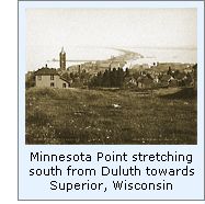 Minnesota Point is a natural wonder,
being the longest freshwater sand bar in the world. Created through the
millennia by silt and sand deposition from the St. Louis River, it is the longest freshwater sand bar in
the world, and its location offshore creates a natural breakwater protecting the
waters of Superior Bay. With the river established as the border
between the states of Wisconsin and Minnesota, the rival ports of Duluth
and Superior grew separately on each side of the river. In the early
1850's, there was but a single opening in the bar, known as Superior
Entry, with all vessels entering either harbor forced to negotiate
this single void. Minnesota Point is a natural wonder,
being the longest freshwater sand bar in the world. Created through the
millennia by silt and sand deposition from the St. Louis River, it is the longest freshwater sand bar in
the world, and its location offshore creates a natural breakwater protecting the
waters of Superior Bay. With the river established as the border
between the states of Wisconsin and Minnesota, the rival ports of Duluth
and Superior grew separately on each side of the river. In the early
1850's, there was but a single opening in the bar, known as Superior
Entry, with all vessels entering either harbor forced to negotiate
this single void. With
the new locks at Sault Ste Marie planned for completion in 1855,
both cities on either side of the river were looking forward to a
dramatic surge in commerce. Realizing that traffic through Superior
Entry would increase dramatically as a result of vessel traffic being
opened up to the lower lakes, Congress appropriated $15,000 for the
construction of a station to light Superior Entry on August 3, 1854.
 A
site for the station on the Minnesota shore approximately three quarters
of a mile from the entry was selected and surveyed in 1855, but work did
not start on the structure until late the following year, with the
delivery of the materials at the site and the laying of the foundation.
Work resumed in 1857 and continued throughout the year until cold
weather set in, and was stopped until the coming of spring. The light
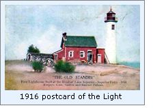
was finally completed in 1858, when RH Barett, the station's first
keeper exhibited the fixed red Fifth
Order Fresnel lens for the first time. A
site for the station on the Minnesota shore approximately three quarters
of a mile from the entry was selected and surveyed in 1855, but work did
not start on the structure until late the following year, with the
delivery of the materials at the site and the laying of the foundation.
Work resumed in 1857 and continued throughout the year until cold
weather set in, and was stopped until the coming of spring. The light
was finally completed in 1858, when RH Barett, the station's first
keeper exhibited the fixed red Fifth
Order Fresnel lens for the first time.
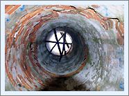
 As
was common with many of the lights constructed during the 1850's, the
great distances involved in the district prevented frequent inspections,
and thus most of the contractors worked largely unsupervised. As a
result, workmanship and materials were frequently less than perfect, and
the completed structures frequently deteriorated rapidly. This appears
to have been the case at Minnesota Point, as Lighthouse Board annual
reports indicate that the station was in a constant state of repair. In
the 1868 report for the station it was stated that "The dwelling
leaks badly around the chimneys. The rain and soot have discolored the
walls. The plastering has fallen in many places, and is loose in nearly
all the rooms." As
was common with many of the lights constructed during the 1850's, the
great distances involved in the district prevented frequent inspections,
and thus most of the contractors worked largely unsupervised. As a
result, workmanship and materials were frequently less than perfect, and
the completed structures frequently deteriorated rapidly. This appears
to have been the case at Minnesota Point, as Lighthouse Board annual
reports indicate that the station was in a constant state of repair. In
the 1868 report for the station it was stated that "The dwelling
leaks badly around the chimneys. The rain and soot have discolored the
walls. The plastering has fallen in many places, and is loose in nearly
all the rooms."
 As Duluth grew through the 1860's, a
strong rivalry began between the two towns at each end of Minnesota
Point. Resenting that vessels making for Duluth had to pass through the
Point at its Wisconsin end, the people of Duluth attempted to build
docks on the outer side of the sand bar, to avoid having to use the
Superior Entry. However, the docks were no match for Lake Superior's
fury, and they quickly deteriorated. The citizens of Duluth petitioned
the Government to construct a canal through Minnesota Point at its
Duluth end. The Army Corps of Engineers conducted a study, and advised
against the project, fearing that water levels behind Minnesota Point
would be adversely affected. Undeterred, a consortium of Duluth
businessmen arranged financial backing from Philadelphia financier Jay
Cooke, and began excavation of the canal independently in 1871. As Duluth grew through the 1860's, a
strong rivalry began between the two towns at each end of Minnesota
Point. Resenting that vessels making for Duluth had to pass through the
Point at its Wisconsin end, the people of Duluth attempted to build
docks on the outer side of the sand bar, to avoid having to use the
Superior Entry. However, the docks were no match for Lake Superior's
fury, and they quickly deteriorated. The citizens of Duluth petitioned
the Government to construct a canal through Minnesota Point at its
Duluth end. The Army Corps of Engineers conducted a study, and advised
against the project, fearing that water levels behind Minnesota Point
would be adversely affected. Undeterred, a consortium of Duluth
businessmen arranged financial backing from Philadelphia financier Jay
Cooke, and began excavation of the canal independently in 1871.
 Representatives of the town of Superior
were awarded a court injunction to end the works, but when Duluth Mayor
J B Culver learned of the decision by telegraph, he organized a flurry
of activity at the site, which managed to bring the project to
completion before the official documentation could be delivered. Thus,
vessels bound for Duluth were able to gain direct entry to the port, and
Superior Entry began to be used only by vessels bound for the Wisconsin
Port. Representatives of the town of Superior
were awarded a court injunction to end the works, but when Duluth Mayor
J B Culver learned of the decision by telegraph, he organized a flurry
of activity at the site, which managed to bring the project to
completion before the official documentation could be delivered. Thus,
vessels bound for Duluth were able to gain direct entry to the port, and
Superior Entry began to be used only by vessels bound for the Wisconsin
Port.
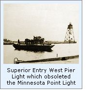
 With the construction of piers at
Superior entry in 1885, the Lighthouse Board determined that the
interests of navigation would be better served with the establishment of
a light on the pierhead. Thus, the old Minnesota Point light was
discontinued on August 6, 1885. However, the old keepers dwelling was
completely refurbished, and continued to serve as the dwelling for the
St. Louis Pierhead Light keeper. With the construction of piers at
Superior entry in 1885, the Lighthouse Board determined that the
interests of navigation would be better served with the establishment of
a light on the pierhead. Thus, the old Minnesota Point light was
discontinued on August 6, 1885. However, the old keepers dwelling was
completely refurbished, and continued to serve as the dwelling for the
St. Louis Pierhead Light keeper. The rivalry between the two cities did
not end with the construction of the canal, but continued with each
seeking to outdo the other with independent funding requests to the
Federal Government. Finally, in 1895, with the formation of the
Duluth-Superior River and Harbor Commission, the two ports were viewed a
single entity by the Government, and both ports worked together to reap
the benefits of shipping the bounties of the Missabe and Vermilion iron
ranges.
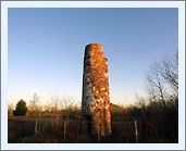
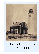
 Also in 1895, the Lighthouse Board
determined that with the completion of new piers at Superior Entry,
navigation would be better served with a light on
the pier on the Wisconsin side of the channel, and a new light and
keepers dwelling were constructed across the channel on Wisconsin
Point. Thus, the Minnesota
Point keepers dwelling was abandoned, and without the constant care of the keepers,
deteriorated rapidly. Also in 1895, the Lighthouse Board
determined that with the completion of new piers at Superior Entry,
navigation would be better served with a light on
the pier on the Wisconsin side of the channel, and a new light and
keepers dwelling were constructed across the channel on Wisconsin
Point. Thus, the Minnesota
Point keepers dwelling was abandoned, and without the constant care of the keepers,
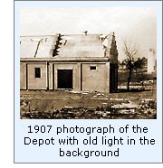
deteriorated rapidly. While the story of Minnesota Point
lighthouse was over at this time, the Lighthouse Board was not yet done
with the property on which it sat. When searching for a location for its
planned Duluth Buoy Depot
in 1902, the Board selected the old lighthouse reservation as the best
location for the new depot, with construction of the depot beginning the following
year.

Keepers of
this Light
Click here
to see a complete listing of all Minnesota Point Light keepers compiled
by Phyllis L. Tag of Great Lakes Lighthouse Research.
Seeing this Light
After
crossing the lift bridge at the canal, continue 4.3 miles to the SE via
S. Lake Ave and then Minnesota Ave. You will come to the Sky Harbor
Airport. Park your car somewhere near the airport entrance and walk
around the airport fence to the N. You will find an unmarked trail
which is known as Park Point Trail. Continue SE on Park Point Trail for
¾ miles alongside the airport. Once you pass the eastern end of the
airport fence, continue ¾ mile southeast to the lighthouse and buoy
depot building 650 feet further to the SE. Note that the trail
starts out hard top, but is eventually pure sand. GPS Coordinates: 46°42'36.01"N x 92° 1'33.08"W
Reference Sources
Annual Reports of the Lighthouse Board, Various reports from 1850
- 1912
Long Ships Passing, Walter Havighurst, 1942.
6/20/01 email from Dan Tomhave on directions to the ruins.
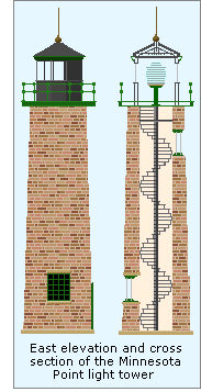
HABS/HAER drawing of the Minnesota Point tower.
Photographs courtesy of Dennis O'hara of Northern Images
Keeper listings for this light appear courtesy of Great
Lakes Lighthouse Research
|