|
|

 |
One of George Washington's dreams was the connection of the Ohio
River with the seaboard. On the one hand via the Potomac River, and on the other hand via
Lake Erie and the St. Lawrence. In a letter to Secretary of War Knox, he mentioned the
very short portage between the upper waters of the Wabash and the Maumee near the site of
Fort Wayne as "the most feasible point for water communications between the Ohio
and Lake Erie." Old Towpaths. Alvin F,
Harlow 1926 D. Appleton Co. |
 On March 2, 1827, Congress granted land to Indiana
equal to one-half of five sections on each side of a canal route, every alternate section
to be reserved to the United States. The donation was generous: 527,271.24 acres in a
strip five miles wide and about 160 miles long from the mouth of the Tippecanoe River to
the Wabash to the mouth of the Auglaize River on the Maumee. The law stipulated that the
canal be commenced within five years, that it be completed in twenty years, and that it be
toll free for all uses of the Federal Government. On March 2, 1827, Congress granted land to Indiana
equal to one-half of five sections on each side of a canal route, every alternate section
to be reserved to the United States. The donation was generous: 527,271.24 acres in a
strip five miles wide and about 160 miles long from the mouth of the Tippecanoe River to
the Wabash to the mouth of the Auglaize River on the Maumee. The law stipulated that the
canal be commenced within five years, that it be completed in twenty years, and that it be
toll free for all uses of the Federal Government.
Indiana Canals.
Paul Fatout. Purdue University Press 1972
 During the winter of 1830, sales of canal lands were
held in Logansport and Lafayette, but the results were disappointing. Forty two thousand
acres were sold, and brought only $75,000, an average of $1.75 per acre, of which one
fourth was cash. .Notwithstanding this fact, a decided canal majority had developed in
Indiana, and in 1832 the project was set in motion. During the winter of 1830, sales of canal lands were
held in Logansport and Lafayette, but the results were disappointing. Forty two thousand
acres were sold, and brought only $75,000, an average of $1.75 per acre, of which one
fourth was cash. .Notwithstanding this fact, a decided canal majority had developed in
Indiana, and in 1832 the project was set in motion.
An estimate had been
prepared, setting the probable cost at $1,081,970. More land was to be sold and the money
realized was to be put in the hands of three fund commissioners who were given power to
act. A loan of $200,000 was authorized."
The Mammoth
Improvement Bill was drawn up, with a plum in it for every Jack Horner in the state, and
Governor Noble signed it on January 27, 1836. By that mad act, Indiana placed her neck in
a yoke of debt which was destined to gall her for half a century and humiliate her in the
eyes of the world.
The bill carried
appropriations aggregating $13,000,000, one sixth of the state's wealth at that time. The
Fund Commissioners were instructed to borrow $10,000,000 on twenty-five years time at 6
percent - a debt of $20 for every man, woman, and child in the State.
The following works
were authorized:

|
The White water canal; also a canal to connect the
White Water with the Central Canal, if practicable; if not, a connecting railroad was to
be substituted. For this work $1,400,000 was set aside. |
|
The Central Canal, leaving the Wabash & Erie
somewhere between Fort Wayne and Logansport, running via Indianapolis and the Forks of the
White River to Evansville. For this $3,500,000. The Wabash Erie was to be extended from
the mouth of the Tippecanoe river down to Terre Haute, and thence via the Eel River to the
Central Canal. $1,300,000 |
|
A railroad
from Madison to Lafayette; a turnpike from New Albany to Vincennes, and a railroad or
turnpike from Jeffersonville to Crawfordsville; each to cost $1,300,000/ $50,000 was to be
spent in improving the Wabash River from its |
|
A survey
was to be made for a canal (if practicable; if not a railroad) from the Wabash & Erie
near Fort Wayne to Lake Michigan at Michigan City; this canal to be begun within ten
years.
Old Towpaths. Alvin F, Harlow 1926 D. Appleton Co. |
An American Land Grab transferred the vast central portion of Indiana to the
United States and required the Indians to leave the land within three years. This
occasioned the departure of the Delawares from Central Indiana in 1820, followed by the
removal of the Potawotamis in the 1830's and the Miamis in the 1840's.
This is partially explained by the influx of white people
into all parts of the state, causing Indiana's population to double and then redouble
between 1820 and 1840, creating a demand for improved transportation routes all over the
state. Most of the Indian treaties after 1820 were formed ostensibly for the purpose of
acquiring land needed for transportation arteries such as the Michigan Road and the Wabash
& Erie canal; and treaties ordinarily provided for a few individual reservations of
land to certain prominent Indian leaders and their families."
The Hoosier State- readings in Indiana History. Ralph
Gray. 1980
The emigration (relocation of the Miami Tribe) finally began at Peru on October 6.
Three canal boats were loaded with baggage, Indians, and white officials. On the second
day, the three boats reached Fort Wayne, where the remainder of the tribe was awaiting the
conductors; two more boats were added to accommodate them.
The party followed the Wabash & Erie Canal to its
junction with the Miami and Erie Canal in Ohio, the passed through Dayton to Cincinnati,
where the entire party was transferred to the steamer Colorado on the Ohio River.
The expedition reached St. Louis on October 20, 1846,
transferred to the Clermont II, and three days later steamed up the Missouri River. The
Indians and baggage were unloaded at Kansas Landing (now Kansas City) on the first of
November and reached the Osage sub agency reservation eight days later.
Meanwhile Joseph J. Comparet of Fort Wayne, who had
contracted with the conductors to deliver the Miamis' horses to the western reservation,
arrived there on November 5. He had left Peru one day after the boat party and had lost
only nine of the original herd of ninety-nine animals in crossing Indiana, Illinois and
Missouri.
The Hoosier State- Readings in Indiana History. Ralph
Gray. 1980
Many Miamis carried with them handfuls of the earth taken from the graves of their
loved ones
Indians of Wabash County. Warder Crow. Wabash Hist.
Museum. 1985

Chief Lafontaine
|
Chief Lafontaine presided over the dissolution of the Miami Nation in Indiana and
its removal to Kansas Territory. He went west with his people in 1846 and died while
returning to Indiana in 1847. He is buried in Huntington. The house in which he held
council is preserved at the "Forks of the Wabash" park in Huntington. |
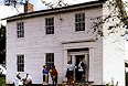
Lafontaine's House
|
|