|
Historical
Information

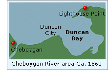
In 1851, Duncan City was the only town of prominence near the
mouth of the Cheboygan River. Located at the western edge of McLeod's
Bay, a little over a mile to the east of the river, where the McLeod
brothers had established the area's first sawmill in 1846.
 Duncan City was a "company
town," and took its name from Jeremiah W. Duncan, whose lumbering
operation eclipsed all others in the area. Duncan's docks along the bay
established it as a fueling stop for the wood-burning steam vessels
passing through the Straits. As Duncan City grew, it did not take long
for the bay itself to take on the Duncan name. Duncan City was a "company
town," and took its name from Jeremiah W. Duncan, whose lumbering
operation eclipsed all others in the area. Duncan's docks along the bay
established it as a fueling stop for the wood-burning steam vessels
passing through the Straits. As Duncan City grew, it did not take long
for the bay itself to take on the Duncan name.
Located directly across the three mile
width of the Straits from the southernmost point of Bois Blanc Island,
the eastern prominence of Duncan Bay marked a natural turning point for
vessels entering the Straits, and the growing bounty of Lake Michigan
beyond.
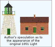 On December 21, 1850, Congress
appropriated the sum of $4,000 for the purchase of a 41.13 acre reservation on what would become known as
"Lighthouse Point" at the western end of Duncan Bay for the
construction of the first Cheboygan light station. The construction
contract was awarded to Rhodes and Warner, of Ohio, and under the
superintendence of Captain Shook of the Army Corps of Engineers,
construction of the station began in the spring of 1851. Consisting of a
round 40-foot brick tower on a stone foundation, the lantern was
outfitted with a Fifth Order Fresnel lens manufactured by L. Sautter of
Paris, making it one of the first on the Great Lakes equipped with a
lens of the Fresnel design. William Drew, the station's first keeper,
took up residence in the detached keeper's quarters, and exhibited the
light for the first time in September, 1851. On December 21, 1850, Congress
appropriated the sum of $4,000 for the purchase of a 41.13 acre reservation on what would become known as
"Lighthouse Point" at the western end of Duncan Bay for the
construction of the first Cheboygan light station. The construction
contract was awarded to Rhodes and Warner, of Ohio, and under the
superintendence of Captain Shook of the Army Corps of Engineers,
construction of the station began in the spring of 1851. Consisting of a
round 40-foot brick tower on a stone foundation, the lantern was
outfitted with a Fifth Order Fresnel lens manufactured by L. Sautter of
Paris, making it one of the first on the Great Lakes equipped with a
lens of the Fresnel design. William Drew, the station's first keeper,
took up residence in the detached keeper's quarters, and exhibited the
light for the first time in September, 1851.
The tower was evidently poorly located,
as high water was found to be undermining the stone foundation soon
after construction. Fearing collapse was imminent, in 1859 the
newly-formed Lighthouse Board decided to build a new station and
demolish the original tower, only eight years after its construction.
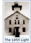 The replacement station, was similar in design to that built at Port
Washington the following year, consisting of a combined keeper's
dwelling and tower, with the tower located at the north apex of the
hipped roof. The tower stood thirty-one feet above the foundation, and
was capped with an octagonal iron lantern into which the Fresnel from
the old tower was carefully relocated. The lights' thirty-seven foot
focal plane provided a twelve mile range of visibility, thereby
providing coverage throughout the Straits. The replacement station, was similar in design to that built at Port
Washington the following year, consisting of a combined keeper's
dwelling and tower, with the tower located at the north apex of the
hipped roof. The tower stood thirty-one feet above the foundation, and
was capped with an octagonal iron lantern into which the Fresnel from
the old tower was carefully relocated. The lights' thirty-seven foot
focal plane provided a twelve mile range of visibility, thereby
providing coverage throughout the Straits.
The arrival of the lighthouse tender
Ruby in the Fall of 1889 was a momentous, but not altogether enjoyable
occasion for the Cheboygan keepers, when the apparatus for duplicate
fog-signals were delivered to the station. The arrival of the fog signal
equipment not only meant more work, but sleepless nights until they
adjusted to the noise!
 The Ruby returned the following Spring
with additional materials and a construction crew, who quickly set about
construction of the new fog signal, close to the lakeshore approximately
one hundred feet to the east of the station. The Ruby returned the following Spring
with additional materials and a construction crew, who quickly set about
construction of the new fog signal, close to the lakeshore approximately
one hundred feet to the east of the station.
All was not bad news for the
keepers,
however, as the construction crew also improved the dwelling with the
installation of running water pumped from a cistern installed in the
cellar, the boat house was relocated from Duncan Bay to the shore in
front of the fog signal building, and a circular iron oil house of
225-gallon capacity was constructed to allow the storage of a year's
supply of oil a safe distance from the dwelling. Finally, with the
construction of plank walkways connecting the new structures to the
dwelling, work was completes on June 2, and the fog signal was placed
into operation. Over the remainder of that year, the fog signals were
operated for a total of 96 hours, their boilers consuming 4 tons of
coal.
 This was the time of peak production
for Cheboygan's lumber industry, with the area's eight mills producing
over 100 million board feet of lumber, of which the Duncan Mill produced
27.5 million feet alone. Thompson Smith took over as the owner of the
Duncan Mill. A religious man, he forbade the construction of any saloons
in his town. It would appear safe to assume that this may have
contributed to the 42 saloons located in Cheboygan in 1895! This was the time of peak production
for Cheboygan's lumber industry, with the area's eight mills producing
over 100 million board feet of lumber, of which the Duncan Mill produced
27.5 million feet alone. Thompson Smith took over as the owner of the
Duncan Mill. A religious man, he forbade the construction of any saloons
in his town. It would appear safe to assume that this may have
contributed to the 42 saloons located in Cheboygan in 1895!
As was the case with most of Michigan's
lumber towns, the boom days were short-lived. The areas forests were
quickly clear-cut, and the lumberjacks began picking up stakes to work
the virgin forests of the west.
 1896 saw the busiest recorded year at
the Cheboygan Main fog signal, as the keepers were kept busy shoveling
thirty-nine tons of coal in order to keep the to keep the signals waling
for a total of 509 hours. The Duncan Mill burned to the ground in
1898, and with the decision not to rebuild, Duncan City's reason for
being disappeared, and the few remaining citizens abandoned the town. 1896 saw the busiest recorded year at
the Cheboygan Main fog signal, as the keepers were kept busy shoveling
thirty-nine tons of coal in order to keep the to keep the signals waling
for a total of 509 hours. The Duncan Mill burned to the ground in
1898, and with the decision not to rebuild, Duncan City's reason for
being disappeared, and the few remaining citizens abandoned the town.
With the construction of the Fourteen
Foot Shoal Light offshore in the Straits in 1930, Cheboygan Main was
considered obsolete, locked-up and abandoned.
With growing vandalism, the old station
was considered to be in dangerous condition and the Coast Guard
demolished the stations buildings at some time during the 1940's. The
Federal Bureau of Recreation conducted a survey of Michigan's coastline
for possible State Parks in 1956, and designated Lighthouse Point as
part of its proposed "Poe Reef State Park Site." In 1958, the
Michigan Department of Natural Resources built the Duncan Bay State
Forest Campground on thirteen acres at Duncan Bay Beach, all of which
was combined to become the current 1,200-acre Cheboygan State Park in
1962.

Seeing this Light
It was a beautiful late spring afternoon as we found ourselves on the
gravel road leading to the Cheboygan State Park entrance. Picking up a
trail map of the park at one of the boxes along the road, we found that
there are a number of trails leading to Lighthouse Point. Without a
great deal of time remaining, we determined that the best trail cut
across the park entrance road, and parked our truck as far off the road
as we could manage, and disappeared into the forest.
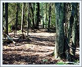
The trail was a
pleasant walk of about a mile and a half through relatively dense woods,
and was easy to follow. We passed the "Poe Reef Cabin," named
for its distant view of the Poe Reef Light, one of three in the park
available for rental.
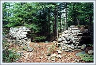
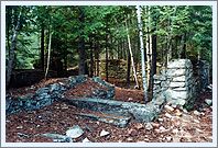
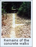
The trail to lighthouse
Point led directly to the old station ruins, which have been surrounded
by a split rail fence. The entire area is now completely overgrown with
pine trees, and we could not even see the lake from the station ruins. We walked down the
cement walk to the shore, and turned to look back at the station.
Everything has become so overgrown that it is hard to imagine that less
than seventy years ago the area was the site of such a historically
significant structure.
Finding this Light
Take
US 23 southeast out of Cheboygan, approximately four miles, and look for
the Cheboygan State Park sign on the left. Turn left, and continue until
the hard surface gives way to gravel. You will see signs for the various
trails on the right side of the road. Each of the trail heads has a sign
with a box containing trail maps attached to it. Just about all of the
trails end up at Lighthouse Point, and represents a walk of about a mile
and a half.
Reference Sources
Photographic
field trip to Cheboygan State Park, 04/30/2001.
USCG Historian's Office -
photographic archives.
Annual Reports of the Lighthouse Board, various 1855 - 1911
The Centennial History of Cheboygan County, Historical Society of Cheboygan,
1976.
Old River Town, Cheboygan Centennial, Ellis N. Olson & Gordon
Turner, 1989.
Wood Butchers of the North, Cheboygan Tribune, July 4, 1978.
Shipwrecks of the Straits Of Mackinac, Dr. Charles E. Feltner
& Jeri Baron Feltner,
Keeper listings for this light appear courtesy of Tom & Phyllis Tag
|